Joanna thought Memorial Day Weekend would be the perfect time for me to come up and she and Seth would drive over to meet me there. We would stay at an inn and all hike together and have a little weekend getaway. Then I would follow them back to Vermont and stay a week. It would be my last stay at their little house in Barre before they moved back to Kentucky.
After I finished my sweep across the southeastern lowland states in March, I set my sights on Marcy. My 50 states summit post page described Marcy as one of only two 5000ers in the Adirondack range and
 |
| Marcy in winter standing heads above the other mountains |
I started watching the weather on the summit a month before. At first, Marcy was still getting snow, and then warmer temps and freeze and thaw conditions with no more snow commenced. I was confidant that that type of weather would persist through May. The long term forecast called for storms and rain until about a week out when it changed to "plenty of sun" for the Memorial Day weekend! But then late in the week it started changing back to rain.
I left for New York on a Thursday afternoon. Just north of Columbus, it started raining. Little did I know it would continue raining for the next three days, finally tapering off on Sunday night.
 Arriving early in Keene Valley on Friday afternoon, I stopped in at a nearby restaurant called the Noon Mark Diner and had a delicious bowl of chili on that rainy cool afternoon. Their chili is made with real hunks of beef instead of ground. It was delicious. They are also known for their wonderful baking of breads, cookies, pastries and pies. The name Noon Mark comes from the owner's ancestors' farm, which in turn is named after a nearby mountain.
 I checked into the Trail's End Bed & Breakfast. It is a big rambling Adirondack house that's been added onto, with beautiful Adirondack stone walls outside. It's fun to imagine what the original house looked like or what life was like here back in the day.
They are an extremely hands off kind of inn. You can check yourself in, if you want to, and not see the owners until breakfast where an employee serves the meal. In fact, you may never see them at all unless you peep through the kitchen door in the morning where she will be cooking and baking. Or if he happens to wander through the inn in the evening while you're downstairs perusing trail books. Or he's coming back from walking the dogs when you're pulling in after a day of hiking.
Another curiosity and kind of refreshing at the same time, is that none of the doors are kept locked, not even your room. No keys are issued. In fact, I accidentally stumbled into someone else's room when I was toting all my clobber through the maze-like hallways upstairs. I sheepishly offered a heart-felt and slightly flustered apology, and the young man assured me that it was no problem.
 After Joanna and Seth arrived, they settled into the room and I checked online for Marcy summit weather again. Snow was forecast for the summit with gale force winds. Really? my unbelieving mind asked. Then I called the High Peaks Office to see if I could glean any more information. The woman I spoke to clearly advised against any kind of hike above 3,000 feet most of the weekend because of stormy weather. I wrote down notes from her weather report and we decided definitely no hike Saturday, maybe Sunday, but probably not until Monday. 60 mph sustained winds! Sheesh! So this is the weather that can rival the blows of New Hampshire's Mt. Washington.
We had a nice dinner at the nearby Ausable Inn, named for the Ausable River that runs through town. We pronounced it "Ossible" until we read the menu and saw that the restaurant spelled it "Au Sable". Then we started calling it "Ah! SaBLUH".
The next morning we awoke to the steady drumming of rain on the roof. Joanna and I snuck down early for coffee and took it into the fireplace room. What a leisurely chat we had. Then we all had a delectable breakfast while discussing a rainy day plan. Seth would study (he had an exam coming up) while Jo and I went to see the town.
 |
| Adirondack Loj - note the roof snow |
As you can see, there is a little snow around. It was wet and heavy.
 |
| Rain-soaked Parking Lot (obviously someone is out hiking) |
 |
| Heart Lake in Background |
 | ||
| Rain-soaked Woods |
 | ||||||||||||||||||||||
| Me At High Peaks Center |
Do we look like the small children in The Cat in the Hat? Because that is how we felt. We were growing antsy and bored waiting for a chance to hike. "The sun did not shine. It was too wet to play. . ." So we sat in the Inn all that cold, cold wet day.


The next day, Sunday, was exactly the same weather. Seth studied, while Joanna and I took a hike at John Brown's farm. John Brown is the abolitionist who thought armed insurrection was the only way to overthrow the institution of slavery in the United States. He led the raid of the armory at Harpers Ferry, Virginia, in 1859 but was caught and later hung for treason. Historians agree that the Harpers Ferry raid, unsuccessful though it was, escalated tensions that a year later led to the Civil War.
I remember that the story in my grade school history book made him out to look like a crazed monomaniacal zealot. I also remember singing the folk song, "John Brown's body lies a-mouldering in the grave" as if that was where he belonged, the scheming traitor! Up in New York, he is hailed as a national hero who gave his own life so that millions of Americans might be free. He is buried here along with his sons who died in the raid. The enclosed tombstone is that of his grandfather who died in New York City fighting for freedom in the American Revolution.
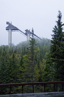
You can see the Olympic high ski jumps in Lake Placid from this farm. They stand out above everything else around them and look much higher than they do on TV during the Olympics.
Next Jo and I went back to the Adirondack store where she had spied a wool blanket in a leather carrier, such that you would take on a picnic, that she just had to have!

This particular store is such a tease, because you see so many cool things that you would put in a camp in the Adirondacks, if only you owned a camp in the Adirondacks!

So she narrowed it down to two blankets. Then she opened them up and looked at them. Then she read the labels. Then she considered how best to keep dog hair off of each one. Then she even smelled them both!

After the smell test, Joanna decided on the blanket in her right hand. Having made her decision, there was no dithering like I would do. She marched to the counter, promptly paid the man and we left.

Back at the inn, Seth still had a bit more studying to do. He had built up a fire in the fireplace room, so Joanna and I decided to bring hot tea and cards and play there by the fire. Lovely rainy day activity!

I also fashioned a little trail map after reading from all the trail books in the inn about the Van Hoevenberg Trail. Just in case we actually got to hike the confounded Mt. Marcy.
Henry Van Hoevenberg was an avid hiker in the Adirondacks during the late 1800s. He was known for leading and teaching many hikers and responsible for building many of the trails there.
 |
| See, he knew to wear snowshoes |
One hike took them atop Mt. Marcy, and from this highest summit they decided to choose the most beautiful place in the valley to build a home. They chose a spot beside a lake that looked to them like a tiny heart-shaped sapphire nestled in the velvety green of the valley trees. They named it Heart Lake.

Then Josephine went back to Toronto, Canada, where she was from, and sadly, where she was engaged to marry a rich man by decree of her father. Mr. Van never heard of her again, except of her sudden death within the year.
There is record, though, of a woman named J.J. Schofield who stopped at Niagara Falls on her way from the Adirondacks to Toronto, and took her own life by jumping over the falls at Goat Island. Could this have been Mr. Van's beloved Jo? He never married and remained in the Adirondack Heart Lake area. He built the Loj beside the lovely lake and named the beautiful small mountain next to the lake Mt. Jo.
 |
| Registering at the Trail Head |
By
Sunday afternoon, the weather reports showed dramatically diminishing winds, a
halt to all precipitation, and clearing weather. Monday showed sunny blue skies
and a high of 69 degrees in Keene Valley. Sunday night we packed our hiking
gear and readied ourselves for an early morning departure.
 |
| Does this pack make me look fat? |
On
the trail by 7 am, we hiked quickly to Marcy dam and there had to shed a few
layers. It was sunny although muddy from the rains. Below the dam there was a
bridge to cross Marcy Creek.


Within a half mile
after Marcy dam, we ran into snow. In another half mile we stopped to put
stabilicers on our hiking boots. Very shortly after that, we were following
only two sets of boot prints that looked like two men hiking together two or
three days before.
 |
| Crossing Phelps Creek |
 |
| Phelps Creek! Isn't it Beautiful! |
 We followed their tracks but very soon our feet were
punching well down below their prints. In hiker's terms, it's called
post-holing.
We followed their tracks but very soon our feet were
punching well down below their prints. In hiker's terms, it's called
post-holing.
As
if the going weren't already slow, the trail began to be blocked by blow-downs,
trees knocked over in the ferocious winds of the storm. As the day grew warmer,
the boughs of the trees under which we hiked gleefully dropped heavy loads of
snow on us as we passed. The more altitude we gained, the deeper the snow until
finally it was up to our hips.
Finally,
we reached the inevitable high altitude sign that warns you against continuing
unless you are 1) sure of fair weather and 2) equipped for the worst weather.
To me this means that emerging from treeline is imminent, and it gave me great hope.
So I was disappointed when, turn after turn in the trail, I still couldn't see
Marcy, or look out from the tunnel of trees at all.

Worry
was gnawing at me. I worried about not being able to summit this simple high
point. I worried about dragging these two out on a hike ill-prepared for this
deep snow. I worried about how much time it was taking and how, much later on
our descent, the snow would be really melting and making little icy rivers of our
forged trail. My worry sapped my energy.
On
one of our powwows we set a mandatory turn-around time. At 2 pm, we would turn
around if we hadn't summited. I said I agreed as long as I wasn't already on
the ledge below the summit. Then I would press on no matter what the time.

Finally
we emerged from the trees. We could see the long ridge going forever up and
winding around to the right and the waiting summit, which still seemed a long
way off.
We
slogged on and on up that ridge, battling the deep snow, but getting ever
closer. I still had thoughts of turning around because we were making such slow
progress. At this point, I knew I could make it, but 2 pm was fast approaching.
Plus I knew there was some rock scrambling to reach the summit. What would that
entail, after this spring snow storm?
 |
| See how happy we are? We are laughing gleefully! |
 |
| The whole day's goal: Marcy Summit |
We were so happy to have made it to Ann's Ledge, that we got out our cameras and started snapping pictures. The race against time was suddenly not an issue. The small mountain behind Joanna is Little Marcy. And the big mountain behind me is, of course, Marcy.

The view from Ann's Ledge was stupendous! We could make out Mt. Mansfield and Camel's Hump in Vermont! We could see into Canada!
We could see all the other high peaks of the Adirondacks! Though for the most part we didn't know which was which. The snow-covered peak in the picture below just left of upper center is Whiteface, used in the Alpine skiing events of the Olympics at Lake Placid.
 The
ledge was so sunny it made it seem warm! It was partly exposed and dry, and
partly under snow. They like you to stay on the rock in this very fragile
alpine environment and we did our best. I still had a few doubts about reaching
the actual summit because there was a lot of snow in the way. This is where
foot prints of any kind disappeared. No one had been here all weekend. But Seth
declared, "We can do this!" and led the way.
The
ledge was so sunny it made it seem warm! It was partly exposed and dry, and
partly under snow. They like you to stay on the rock in this very fragile
alpine environment and we did our best. I still had a few doubts about reaching
the actual summit because there was a lot of snow in the way. This is where
foot prints of any kind disappeared. No one had been here all weekend. But Seth
declared, "We can do this!" and led the way.
 Up we went scrambling
over snowy boulders and trying to not trample the alpine vegetation, or worse,
trying not to slip and fall into a snow-filled fir tree ravine. Joanna hung
back a little to take our summit picture. The last 100 yards were easy.
Up we went scrambling
over snowy boulders and trying to not trample the alpine vegetation, or worse,
trying not to slip and fall into a snow-filled fir tree ravine. Joanna hung
back a little to take our summit picture. The last 100 yards were easy.


And
this is me with the highpoint plaque. I'm not even sure what it says. We were
taking pictures quickly because it was cold on the summit and we were wet. It
was about 29 degrees with 20 mph winds. This is my 30th high point!
Too
soon, we knew we had to get back down that 7.4 miles. Let me just say that the
way down was even worse than the way up except for the fact that we were
descending. The snow was melting fast and the trail gushed with slushy water.
Every step we took only made it worse as we dislodged ice dams that sent a
cascade of icy water up to the knees of the person in front of you. Because of
the deep snow cover, we couldn't see the bogs and trudged right through them
plunging into water and hitting mud that threatened to pull off your hiking
boot as you lifted your foot out. In the end Joanna DID lose one of her
stabilicers.
When
we got below 3,000 feet, there were other people hiking about. I wondered why?
If I hadn't been doing something big, like summiting the highest mountain in
the state, I would not have been out hiking in these muddy rivers of slush that
were trails. I guess it being a holiday, people just wanted to get out in the
woods no matter what.
We
were dreading the blow down area, but we saw that a trail maintenance crew had
already been through to clear the trail. The poor trees looked like a big
monster had come through and chewed them up and spit them back out! We saw
humor in the violently splintered wood and pine needles littering the snow.

By the time we got to
Marcy Dam, Joanna was finally losing steam. That last 2 1/2 miles were probably
the longest for her. Seth and I kept saying things like, "Oh, it can't be
more than another half mile" and "I think I see a clearing in the
trees ahead, must be the Loj!" I wasn't shocked that she didn't
believe anything we said.
Here
we are at the end. Muddy and wet and exhausted. But happy and proud and
victorious! Marcy nearly beat us, but we got the last laugh.
To read my daughter Joanna's account of this trip, please see http://snowflowerjo.blogspot.com.
To read my daughter Joanna's account of this trip, please see http://snowflowerjo.blogspot.com.


