"I'm not sure," Joanna said.
"One of the facial parts is higher than the others, and therefore the summit. We only need the summit."
One day later, Mt. Washington was a thing of the past, a fading memory of a conquered mountain, just another high point to be checked off, the digital pictures left forgotten in the camera to be viewed later. That is, until I stood up from anywhere I was sitting, and my screaming muscles reminded me that I only came off that summit less than 18 hours ago. Still, I had limited time left in Vermont and Mt. Mansfield was in my crosshairs.
 |
| Mount Mansfield, Vermont |
It was a beautiful Sunday morning in late May. Joanna and I were out on the patio in her back yard under the huge spreading maple tree. The sun was warm, the breeze balmy, the coffee hot, I had my laptop and she had the Wall Street Journal.
"Isn't this the life? A leisurely morning sitting outside with a pot of coffee and the Wall Street Journal. Ahhhhhh, isn't this blissful?"
Poor Joanna woke up with her left eye swollen shut. One of those nasty black flies bit her near her eyelid and it swelled up in her sleep.
Yesterday coming down the mountain the voracious critters were finding anywhere to bite that wasn't covered in clothing or had bug spray on it. I remember slapping the back of my neck only to bring my hand away with blood smeared on it. "Are there black flies on my neck?" I asked Jo, who was walking behind me.
"OH my God, Mom. You have 4 bites on your neck. No, you have 5! Five bites on your neck. Wait, move your hand. Six! You have six black fly bites on your neck!" We stopped right there to get the bug spray out again. Joanna covered her neck with her bandana as well. Too late, of course, but they pretty much stopped bothering us, although they still swarmed around our eyes. You can't put bug dope on your eyes!
Hence, Joanna's swollen eye. She wore sunglasses all day Sunday.
"So it says here that "when viewed from the east or west, this mountain has the appearance of a (quite elongated) human profile, with distinct forehead, nose, lips, chin, and Adam's apple. These features are most distinct when viewed from the east; unlike most human faces, the chin is the highest point." So I guess we go for the chin. We don't need the forehead or nose, I'm going straight for the chin. Let me see which trails go there."
"What is a madagascan tree climber, 5 letters?" Joanna asked. She had moved on to the Sunday Crossword.
"Hmmm, not sure. The Long Trail! The Long Trail goes straight to The Chin. Looks like we drive toward Stowe and then take VT 108 to the trail head. 2 1/2 miles to the summit. That shouldn't be bad at all, after Washington.
The Long Trail (273 miles) was built by the Green Mountain Club between 1910 and 1930, and is the oldest long-distance trail in the United States. It follows the main ridge of the Green Mountains from the Massachusetts-Vermont line to the Canadian border as it crosses Vermont's highest peaks. It was the inspiration for the Appalachian Trail, which coincides with it for one hundred miles in the southern third of the state.
"Let me check the weather for tomorrow. Are you sure you want to hike with me?"
With only one good eye and sore legs, I wasn't sure she really wanted to come.
"Of course I want to hike. Important layer, 12 across, what is an important layer, five letters?"
"Okay, just making sure. Important layer, hmmm. Are you just hiking it so you can tell your friends?"
I remembered our conversation from earlier in the week. It seemed some Vermont acquaintances of hers thought that hiking Mansfield was the hike to end all hikes. They taunted, "Yes, we grew up on these mountains, we've played on them in the summer, and skied on them in the winter. Mansfield is a tough and rugged mountain! You have to be hardy to hike Mansfield!"
"Yes. I have to be hardy."
"But you just hiked Washington. It's nearly 2,000 ft. higher!"
"I know. But that wouldn't phase them. They would still think that Mansfield is more rugged and somehow harder."
"But Washington has dangerous weather patterns. And violently strong wind gusts."
"Wouldn't matter to them. Some are tributarios, 4 letters."
"What are tributarios?"
So we settled on the Long Trail hike and I checked the weather. It was to be fair with one isolated thunderstorm around noon. I thought if we got our butts out of bed and hiked in the morning we could be finished by the time that thunderstorm arrived.
Monday morning, Memorial Day, dawned sunny and bright with the promise of a warm day. We discussed our ascent over a less leisurely coffee hour than Sunday, and started packing up lunch, snacks, and water in our day packs. No crossword today because of time and because it had accidentally gotten wet yesterday and was drying.
"Don't forget the bug spray!" Joanna cautioned. I had it, but I'm not sure how much was left after Saturday's hike. Her poor eye was still swollen shut. I only assumed so because she sported sunglasses at 7:30 a.m.
I checked the weather one last time. That passing thunderstorm still stubbornly sat in the forecast. Oh well, we just have to get moving. "Don't forget some kind of rain slicker, Jo."
I don't think Thunder minded being left out of this hike. While we busied ourselves with packing he only looked up from his bed looking mildly curious instead of bounding around the house, wagging ferociously.
We piled into Joanna's Forerunner and drove up I-89 towards Stowe, and then onto Vermont 100. When we turned onto Vermont 108 we could see Mansfield rising up calmly behind the quaint Stowe village, made famous by the Von Trapp family settling there in the 1940's.
"I think it's a reach, calling that the profile of a man," Joanna pointed out.
"I agree. That's an awful profile. But look--the chin doesn't look too high, does it?"
We found a place to park not far from the Long Trail where it crossed Vt. 108. As we got out of the car to use the restroom Joanna announced, "I don't think I'll be able to climb this mountain today."
My heart fell. "Why!?" I looked at her and she was grinning.
"Because I can't even walk!"
We both laughed. Our legs were stiff from sitting in the car, true. I hoped that with some stretching we both would feel better and be able to hike.
We signed in at the trail head and started up. Since it was a short hike, I knew it would be steep. And it was. Relentless uphill climbing to reach the 4,395 ft. chin. With an elevation gain of 2,800 feet in 2.3 miles, there was plenty of up.
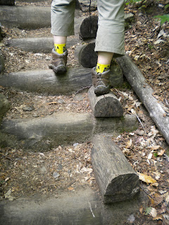
 In some places at the beginning, some kind humans put these wooden steps in place for us.
Joanna invented a way to climb the steps without having to lift her weary legs too high.
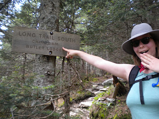
With .6 miles to go we are happy to reach the Butler Lodge at 3,040 ft. Joanna delights in seeing the distance to The Chin!

Mount Mansfield is one of two places in Vermont where Arctic Tundra can be found; the other place being Camels Hump. The extreme climatic conditions along the ridge line support this growth. There are about 200 acres of Arctic Tundra on Mount Mansfield; Camels Hump only holds a few acres. And they like to protect it.
This is a closeup of the sign above. "Au secours!" complain the despairing little plants. I don't speak French, but even I understand the plant's desperate cry for help. It's in French since we are close to the Canadian border and because obviously they don't trust the French not to smash the tundra with their uncaring boot-clad big feet.
As we reached the alpine area, we also started to encounter clouds of gnat-like flies. No fun--feeling them buzz around my sweaty face.
"Are these black flies?" I asked alarmingly.
"No, they are grey."
"I mean, are they the black flies? Are they going to start biting?" They were awfully annoying.
"No, they aren't black flies. They are grey. They are harmless gnats or something. They can't be black flies if they are grey." Joanna spoke with the sort of confidence that, as if by saying so, made it true.
This conversation repeated itself every time we came upon another patch of flies. "Are these black flies?!"
"No, Mom. Look at them, they are GREY." Joanna was losing patience.
I think a "cloud of black flies" is a very apropos choice of words. Besides being "a visible collection of particles", cloud is also defined as "anything that obscures or darkens something, or causes gloom, trouble, suspicion, disgrace, etc." The silly gnats were surely causing me suspicion, gloom, and trouble.
.jpg)
 We were now just below the chin. After a bit a rock scrambling and bouldering, we made it. This is us on the summit!
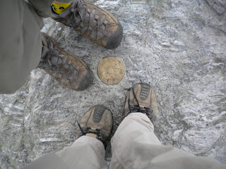
This is the obligatory boot shot of the summit marker.
If Thunder had been with us, surely we would have taken a boot/paw shot of the benchmark as these people did.
The view is astounding and endless but we didn't have much time to find this out because remember the isolated thunderstorm? Well the pesky thing was quickly heading our way. I figured we had about 3 minutes to snap some pictures and scramble back off the unprotected summit. Wouldn't want to boulder down rain slick rocks.
 This picture isn't mine. But I love it because it depicts someone sitting on the top edge of the chin, and looking towards the other peaks: lower and upper lip, nose, and forehead. The Long Trail traverses the entire ridge. Those transmitting towers sit atop the nose. The auto toll road also goes to the nose with a Visitor Center on top. Also, Stowe Ski Resort's gondola goes to the nose with a Cliff House restaurant and with ski fields down the east flank of the mountain. The nose is a busy place. There is even a mountain chapel. I read somewhere that in Spring when the snow melts the skiers call it the Runny Nose!
Once we got down the rocky part the rain passed as quickly as it came, and we looked around for a place to eat our lunch. I suggested going back to the summit. The sun was coming out. We could enjoy the view. They say you can see the Adirondacks in New York, Lake Champlain, the Green Mountains and the White Mountains of New Hampshire. But the idea of climbing back up those rocks didn't appeal to Joanna at all. I looked around.
 |
| The Adam's Apple |
Joanna said no, we would have to go up.
"That's more like across. It's actually lower than where we are here."
"But look at the trail. It goes down and then back up to the adam's apple."
"But look! There are some folks hiking there for lunch." I had noticed a bunch of young hikers from the very nearby Taft Lodge making their way. They had only 40 minutes before been rousing themselves from sleep when we passed the lean to. I could just imagine their noble plans made around the campfire the night before, probably emboldened with liquor. "HEY, I've got an idea: tomorrow let's hike up to the Adam's Apple for lunch!"
Joanna looked around and found a nice perch on a couple of rocks right where we were. We had our lunch and joked about the weather, the grey flies, the facial parts of the mountain, particularly the adam's apple, and how the true summit was still so very close, yet neither of us wanted to go back up, content with the view from where we were. A little bird sang from the treeline tree tops just a few feet away. Life was peaceful.
 On our way down we passed the trail to the adam's apple. You can just make out a day hiker headed for the top.
Here is Profanity Trail, so named for the expletives you voice when you run into unexpected hazardous summit conditions and have to bypass the chin!
 |
| Fiddleheads |
 Below is a tiny field of fiddleheads. They love to eat them in New England in Spring. (See my blog from 6/5/2011)
And here is my Joanna headed down. She's always smiling on the way down. But she has reason. Life is Peaceful. Vermont is Beautiful. Mom didn't pick any fiddleheads to take home and eat for dinner. Her eye is still puffy, but she has these oh so cool sunglasses to hide the puffiness. But mostly. . . mostly because she is now Vermont-hardy. Not New Hampshire or anywhere else, because it doesn't count. Just Vermont.


